|
|
|
|
World Geodetic System 1984 (WGS 84) |
Hartbeesthoek 94 The New South Africa Datum
![]() Background
Background
The co-ordinate reference system, used in South Africa as the foundation for all surveying, engineering and geo-referenced projects and programmes, is the Cape Datum. This Datum is based on the Clarke 1880 ellipsoid and has its origin point at Buffelsfontein near Port Elizabeth. The Cape Datum is based on the work of HM Astronomers Sir Thomas Maclear, between 1833 and 1870, and Sir David Gill, between 1879 and 1907, whose initial geodetic objectives were to verify the size and shape of the Earth in the Southern Hemisphere and later to provide geodetic control for topographic maps and navigation charts. From these beginnings, this initial network was extended to eventually cover the entire country and now comprises approximately 29 000 highly visible trigonometrical beacons on mountains, high buildings and water towers as well as approximately 20 000 easily accessible town survey marks.
As with other national control survey networks throughout the world, which were established using traditional surveying techniques, flaws and distortions in these networks have become easily detected using modern positioning techniques such as the Global Positioning System (GPS). In addition to these flaws and distortions, most national geodetic networks do not have the centre of their reference ellipsoids co-incident with the centre of the Earth thus making them useful only to their area of application. The upgrading, recomputation and repositioning of the South African co-ordinate system has thus been driven by the advancement of modern positioning technologies and the globalization of these techniques for navigation and surveying.
As from the 1st January 1999, the official co-ordinate system for South Africa will be based on the World Geodetic System 1984 ellipsoid, commonly known as WGS84, with the ITRF91 (epoch 1994.0) co-ordinates of the Hartebeesthoek Radio Astronomy Telescope used as the origin of the system. This new system will be known as the Hartebeesthoek94 Datum.
At this stage all heights will remain referenced to mean sea level, as determined in Cape Town and verified at tide gauges in Port Elizabeth, East London and Durban.
![]() Geoids &
Ellipsoids
Geoids &
Ellipsoids
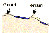
The earth's physical surface is a tangible one encompassing the mountains, valleys, rivers and surface of the sea. It is highly irregular and not suitable as a computational surface. A more smoothed representation of the earth is the Geoid. There are a number of definitions for this surface; a descriptive one is as follows : ‘that surface that would be assumed by the undisturbed surface of the sea, continued underneath the continents by means of small frictionless channels.'
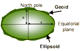
The Ellipsoid is a smooth mathematical surface that best fits the shape of the geoid and is the next level of approximation of the actual shape of the earth.
Elements of an ellipse a = Semi Major Axis
b = Semi Minor Axis
f = Flattening = (a-b)/a
PP’ = Axis of revolution of the earth's ellipsoid
Below is a list of commonly used ellipsoids used in southern Africa and their associated parameters.
Ellipsoid a b Unit Used
Mod. Clarke 1880 6378249.145 6356514.967 International meters R.S.A., Botswana, Zimbabwe WGS 84 6378137.000 6356752.314 International meters Globally Bessel 6377397.155 6356078.963 German Legal meters Namibia Clarke 1866 6378206.400 6356584.467 International meters Mozambique
![]() Datums
Datums
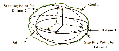
A National geodetic co-ordinate system is defined by a Geodetic Datum, which consists of two parts: a) A defined geodetic reference ellipsoid, in terms of the a,b or a,f parameters. b) A defined orientation, position and scale of the Geodetic system in space. From this, it can be deduced that a specific ellipsoid can be used to define an infinite amount of datums. This is demonstrated in the figure below.
The Cape Datum a) The Modified Clarke 1880 is the reference ellipsoid. b) The initial point for the existing South African Datum is the Buffelsfontein trigonometrical beacon, near Port Elizabeth. c) The orientation and scale characteristics were defined by periodic astronomic azimuth and base line measurements. The Hartebeesthoek94 Datum
a) The WGS84 is the reference ellipsoid. b) The initial point is the Hartebeesthoek Radio Astronomy telescope, near Pretoria. c) The scale and orientation characteristics were defined within the GPS operating environment and has been confirmed and has been confirmed to be co-incident with ITRF91 determination.
![]() Ellipsoidal
Co-Ordinates
Ellipsoidal
Co-Ordinates
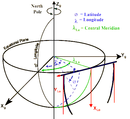
The three dimensional (real world) co-ordinates of a point on the earth’s surface can be defined in: Geographical co-ordinates
- Latitude(Ø : angular displacement north/south of the equator.
- Longitude(
) : angular displacement east/west of the Greenwich meridian.
- Height (H) : either orthometric (height above mean sea level) or ellipsoidal (height above ellipsoid).
Geocentric Cartesian co-ordinates A three-dimensional Cartesian co-ordinate system (Xg, Yg, Zg) with its origin coinciding with the centre of the reference ellipsoid/Earth, and axes as shown below.
The following are examples of geographical co-ordinates and equivalent Cartesian co-ordinates in South Africa (Cape Datum).
Cape Town Geographical 34° 12’54" S 18° 30’45"E Ht = 0.0m Cartesian 5006849 Xg 1676482 Yg -3565925 Zg Johannesburg Geographical 26° 20’00" S 28° 12’00" E Ht 1000.0m Cartesian 5041892 Xg 2703400 Yg -2812717 Zg Durban Geographical 30° 20’ 00" S 31° 12’ 00" E Ht = 0.0m Cartesian 4712938 Xg 2854257 Yg -3202070 Zg
![]() Projected
Co-Ordinates
Projected
Co-Ordinates
Plane co-ordinates are the simplest type of co-ordinates to use for everyday practical applications. To achieve this simplicity, the ellipsoidal latitude and longitude co-ordinates, or 3-D geocentric co-ordinates, must therefore be projected onto a plane surface. It is not possible to do this without some distortion. This can be demonstrated by cutting a tennis ball in half and attempting to flatten it.
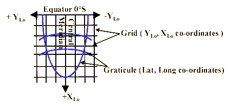
Projections which have the properties of preserving angles and shapes are called Conformal or Orthomorphic projections. In South Africa the Gauss Conform Projection (an adaptation of the Transverse Mercator projection) is used for the computation of the plane YLo, XLo co-ordinates, commonly known as the "Lo. co-ordinate system".
Here the equator will project as a straight line, at right angles to the central meridian (Lo.), but all other meridians and parallels will project as curved lines. The equator and the Lo. are the origins of the YLo and XLo axes of our plane rectangular co-ordinate system. The figure, above, shows the relationship between plane (Lo.) co-ordinates and geographical co-ordinates.
In the South African plane co-ordinate system only the area within one degree of longitude on either side of the central meridian is projected. The width of each segment, often referred to as a belt, is thus two degrees of longitude and is referred to the central meridian of that belt.
![]() Datum
Relationships
Datum
Relationships
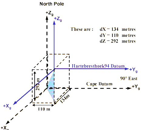
Geocentric Cartesian co-ordinates in South Africa
For comparative purposes the simplest form of transformation, being a geocentric Cartesian translation between the two Datums’ ellipsoid geocentres, will be used
Figure - The ellipsoid relationships
The translations were determined by computing the Hartebeesthoek94 Datum and the Cape Datum co-ordinates of a number of accurately determined trigonometrical beacons.
Note: These transformation parameters will yield co-ordinates in the other datum with residuals that should not exceed 15 metres. Geographical co-ordinates in South Africa
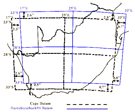
The Hartebeesthoek94 Datum(WGS84) latitude is always numerically greater than its Cape Datum(modified Clarke 1880) counterpart at a point of interest. The magnitude of this difference ranges from approximately 9" at the equator to approximately 0" at latitude 37° South.
The Hartebeesthoek94 Datum(WGS84) longitude is always numerically less than its Cape Datum(modified Clarke 1880) counterpart at a point of interest. The magnitude of this difference ranges from approximately 2" at 15° east of Greenwich to 0" at approximately 39° east of Greenwich.
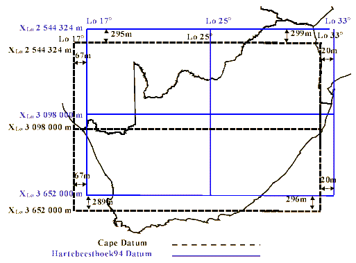
Gauss conform co-ordinates (Lo system) in South Africa
The Hartebeesthoek94 Datum(WGS84) XLo co- ordinate is between 290 and 300 metres greater than its Cape Datum(modified Clarke 1880) counterpart at a point of interest. This difference is directly related to the displacement in the equatorial planes of two ellipsoids.
The Hartebeesthoek94 Datum(WGS84) YLo co-ordinate will always be algebraically greater than its Cape Datum(modified Clarke 1880) counterpart, at a point of interest. The magnitude of this difference ranges from approximately 70 metres at 15° east of Greenwich to 0 metres at approximately 39° east.
The relationship between the longitude differences and Gauss conform YLo co-ordinate differences are opposite in sign. The reason for this is that longitude, by convention, increases eastward and the projection YLo co-ordinate, by definition, increases westwards. Effectively the relationship is the same.
![]() Who will be
Affected
Who will be
Affected
a) Hikers and Navigators This group of users are least effected since the accuracy they require generally exceeds 50m. They should at least be aware of the how the two Datums’ relate to each other. b) GIS practitioners and other users of Geospatial Information Databases In general,these users require a level of accuracy not better than 10cm. The impact on GIS databases depends on : 1. The accuracy of the co-ordinates in the database at present. 2. The purpose of the database. 3. The extent of the database (e.g. local authority, provincial, national). c) Surveyors, Engineers, Architects etc. In general,these users require data to the centimetre level of accuracy .This category of users will be most affected and must follow a meticulous approach.
![]() Transformation
Strategy
Transformation
Strategy
Although the advantages of adopting a new horizontal datum are evident, many users have huge geographically referenced datasets based on the Cape Datum and need to transform these to the new datum. To do this, one needs to establish the relationship between the two datums as this is not absolutely defined.
Various methods of transformation are available in order to transform current data sets, referenced with respect to the Cape Datum, to the new Hartebeesthoek94 Datum.
Because of computational limitations, there are many distortions in the Cape Datum co-ordinates which have been removed in the computation of Hartebeesthoek94 Datum co-ordinates. For this reason the higher the transformation accuracy required, the more localised the area must be for which transformation parameters are calculated. For high end users, such as Land Surveyors and Engineers, transformation accuracy is of paramount importance. Low accuracy GIS applications may however not require this accuracy and parameters covering larger areas may be acceptable.
Transformation parameters
In computing transformation parameters one would require co-ordinates of control points in both datums. The 29 000 trigonometrical beacons and 22 000 town survey marks will serve this purpose adequately.
At least two (for 2-D) or three (for 3-D) points, known in both the old and the new Datum, must be used to determine the transformation parameters and must be well distributed through the area to be transformed.
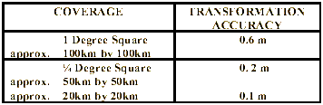
The Chief Directorate: Surveys and Mapping has evaluated two-dimensional Helmert (4 parameter) transformation parameters, derived from the horizontal control survey network data within the two datums, over various sized areas. The averaged residuals obtained are as follows:
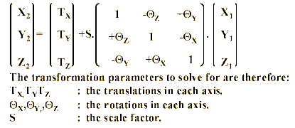
The most common transformation models are Helmert ( for two dimensional transformations) and Bursa Wolfe (for three dimensional transformations).
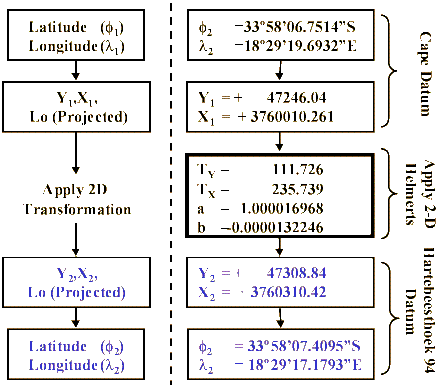
Two dimensional ( Helmert transformation model) system 2 system 1 Y2 = TY + b.X1 + a.Y1 X2 = TX + a.X1 - b.Y1 The transformation parameters to solve for are therefore: TX, TY : The translations in each axis. a, b : Helmert transformation variables. An Example
Transforming a co-ordinate (on Lo19º) from Cape Datum to the Hartebeesthoek94 Datum using predetermined parameters.
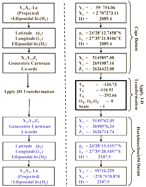
Three Dimensional (Bursa Wolfe transformation model)
system 2 system 1
An Example
Transforming a co-ordinate (on Lo27º) from the Cape Datum to the Hartebeesthoek94 Datum using predetermined parameters.
![]() Conclusion
Conclusion
The Cape Datum has served its purpose well over the last century. With the advent of artificial satellite surveying techniques this Datum has proved to be inadequate for our future needs. The introduction of the Hartebeesthoek94 Datum will ensure that South Africa remains at the forefront of modern geodetic networks and provides us with a Datum that is internationally related and relevant to our user needs.
![]() What will be
Available to Users?
What will be
Available to Users?
- A helpdesk at the office of the Chief Directorate: Surveys and Mapping.
- Co-ordinate lists of all trigonometrical beacons and town survey marks on the Hartebeesthoek94 datum (WGS84 ellipsoid).
- Co-ordinates on the Cape datum (mod. Clarke 1880 ellipsoid ) will be made available for reference purposes.
- Equations/algorithms of required conversions and transformation to assist users wishing to carry their own conversions/transformations.
- Software to transform ASCII co-ordinate files from the Cape Datum to the Hartebeesthoek94 Datum, referred to as "The 1999 Datum Transformation Software", aimed at supporting GIS users.
- Revised and updated triangulation and town survey plans.
- Please note that mean sea level (MSL) will remain the reference surface for all heighting purposes.
Further information, please contact :
R. Wonnacott, WGS84 Co-ordinator
Telephone: +27 (0)21 685 4070 Fax: +27 (0)21 689 1351 E-mail: dmapping@sli.wcape.gov.za Address: Private Bax X10, Mowbray, 7705 South Africa